Choose your own
Adventure
open source spatial
with
Leaflet
and
OpenShift

spatial web stack options
Languages:
- Python
- Java
- Nodejs
- PHP
- Ruby
Databases:
- PostgreSQL + PostGIS
- MongoDB
25 mins!
Agenda
"the Cloud"
what is it made of?
The cloud is:
- hot air?
- a series of tubes?
- mostly cat photos✓
Infrastructure
as a service
inputs:
- Hardware: racks, fiber, routers, storage, compute
- Software: OpenStack, Eucalyptus, CloudStack, SaltStack
Result:
- Easy on-demand Linux environments
Platform
as a service
inputs:
- Hardware: IaaS
- Software: SELinux, CGroups, Docker, HAProxy, ssh, git
Result:
- Horizontally scalable application architectures on-demand
Providing standards-based, open source workflows that answer the question of:
"How do I
Build,
Host,
&
Scale
in the
Open Cloud?"
Terminology (Red Hat)
- Broker – Management host, orchestration of Nodes
- Node – Compute host containing Gears
- Gear – Allocation of fixed memory, compute, and storage resources for running applications (SELinux, CGoups)
- Cartridge – A technology, framework, or application: Python, Ruby, Javascript, PHP, Perl, Java/JEE, PG, MySQL, Jenkins, PHPMyAdmin, etc.
An Open Cartridge format
OpenShift Release Schedule
Frameworks
- NodeJS / Restify:
https://github.com/ryanj/restify-base - Python / Flask:
https://github.com/ryanj/flask-base - PHP / Silex:
https://github.com/ryanj/silex-base - Ruby / Sinatra:
https://github.com/ryanj/sinatra-base
Language-specific Dependencies
Automatic support for dependency resolution using standard packaging, native to each language:
eggs (python), gems (ruby), composer (php), and npm modules (node.js)
Language-specific DB bindings
For nodejs:
npm install pg-query --savebrianc's pg-query module makes working with PG exceedingly simple
Just map your queries to their related callback functions.
Local development
Resolve dependencies:
npm installFire up a local server:
npm startLeaflet
Include a link to Leaflet's css stylesheet and javascript code in your index.html file:
<link rel="stylesheet" href="//cdn.leafletjs.com/leaflet-0.7.3/leaflet.css" />
<script src="//cdn.leafletjs.com/leaflet-0.7.3/leaflet.js"></script>
Initialize the map:
var map = L.map('map').setView([37.8, -122.3], 10);
var markerLayerGroup = L.layerGroup().addTo(map);
L.tileLayer('http://{s}.tile.stamen.com/terrain/{z}/{x}/{y}.png', {
  maxZoom: 18,
  minZoom: 5,
  attribution: 'Map tiles by <a href="http://stamen.com">Stamen Design</a>, under <a href="http://creativecommons.org/licenses/by/3.0">CC BY 3.0</a>. Data by <a href="http://openstreetmap.org">OpenStreetMap</a>, under <a href="http://creativecommons.org/licenses/by-sa/3.0">CC BY SA</a>.'
}).addTo(map);
Update the Map on load, drag, or zoom:
function getPins(e){
  bounds = map.getBounds();
  url = "parks/within?lat1=" + bounds.getSouthWest().lat + "&lon1=" + bounds.getSouthWest().lng + "&lat2=" + bounds.getNorthEast().lat + "&lon2=" + bounds.getNorthEast().lng;
  $.get(url, pinTheMap, "json")
}
function pinTheMap(data){
  //clear the current pins
  map.removeLayer(markerLayerGroup);
  //add the new pins
  var markerArray = new Array(data.length)
  for (var i = 0; i < data.length; i++){
park = data[i];
markerArray[i] = L.marker([park.lat, park.lon]).bindPopup(park.name);
  }
  markerLayerGroup = L.layerGroup(markerArray).addTo(map);
}
map.on('dragend', getPins);
map.on('zoomend', getPins);
map.whenReady(getPins);
Building an API
var config      = require('config'),
restify     = require('restify'),
var app = restify.createServer()
app.use(restify.queryParser())
app.use(restify.CORS())
app.use(restify.fullResponse())

// Routes
app.get('/parks/within', db.selectBox);
app.get('/parks', db.selectAll);
// Static assets
app.get(/\/(css|js|img)\/?.*/, restify.serveStatic({directory: './static/'}));
app.get('/', function (req, res, next)
{
  var data = fs.readFileSync(__dirname + '/index.html');
  res.status(200);
  res.header('Content-Type', 'text/html');
  res.end(data.toString().replace(/host:port/g, req.header('Host')));
});

app.listen(config.port, config.ip, function () {
  console.log( "Listening on " + config.ip + ", port " + config.port )
});
PG Setup
Add Postgres to existing apps:
rhc cartridge add postgres-9.2Or, add MongoDB:
rhc cartridge add mongodb-2.4done!
function select_box(req, res, next){
  //clean our input variables before forming our DB query:
  var query = req.query;
  var limit = (typeof(query.limit) !== "undefined") ? query.limit : 40;
  if(!(Number(query.lat1)
&& Number(query.lon1)
&& Number(query.lat2)
&& Number(query.lon2)
&& Number(limit)))
  {
res.send(500, {http_status:400,error_msg: "this endpoint requires two pair of lat, long coordinates: lat1 lon1 lat2 lon2\na query 'limit' parameter can be optionally specified as well."});
return console.error('could not connect to postgres', err);
  }
  pg('SELECT gid,name,ST_X(the_geom) as lon,ST_Y(the_geom) as lat FROM ' + table_name+ ' t WHERE ST_Intersects( ST_MakeEnvelope('+query.lon1+", "+query.lat1+", "+query.lon2+", "+query.lat2+", 4326), t.the_geom) LIMIT "+limit+';', function(err, rows, result){
if(err) {
  res.send(500, {http_status:500,error_msg: err})
  return console.error('error running query', err);
}
res.send(rows);
return rows;
  })
};
Env Vars
For writing Clean and Portable Code
rhc app show mapappOr, while connected over ssh:
env | grep DBOPENSHIFT_POSTGRESQL_DB_PASSWORD=lXcFVx4hIZgR
OPENSHIFT_POSTGRESQL_DB_SOCKET=/var/lib/openshift/523672f7e0b8cd02d70003bc/postgresql/socket/
OPENSHIFT_POSTGRESQL_DB_HOST=127.7.8.130
OPENSHIFT_POSTGRESQL_DB_PID=/var/lib/openshift/523672f7e0b8cd02d70003bc/postgresql/pid/postgres.pid
OPENSHIFT_POSTGRESQL_DB_USERNAME=adminpahue6e
OPENSHIFT_POSTGRESQL_DB_URL=postgresql://adminpahue6e:lXcFVx4hIZgR@127.7.8.130:5432
OPENSHIFT_POSTGRESQL_DB_PORT=5432
OPENSHIFT_POSTGRESQL_DB_LOG_DIR=/var/lib/openshift/523672f7e0b8cd02d70003bc/postgresql/log/Persist configuration details,
while keeping your source clean:
module.exports = {
  port: process.env.PORT || process.env.OPENSHIFT_NODEJS_PORT || 3000,
  ip: process.env.OPENSHIFT_NODEJS_IP || '127.0.0.1',
  pg_config: process.env.OPENSHIFT_POSTGRESQL_DB_URL || 'postgresql://127.0.0.1:5432',
  table_name: process.env.OPENSHIFT_APP_NAME || process.env.PG_MAP_TABLE_NAME || 'parks'
}
Environment Variables
Listing your custom env vars:
cd myapp
rhc env list
Setting a variable:
rhc env set SECRET_TOKEN="a1fdacc3b1d14d6a92ed1219ed304d02529f535085262a90c39f072ef6de0ee9fe3a3d0194f02a2a8eb3"Help with configuration:
rhc help envOr, supply additional keys during the app creation process:
rhc app create hydrant ruby-1.9 postgresql-8.4 --from=code=http://github.com/ryanj/adopt-a-hydrant.git --env SECRET_TOKEN="YOUR_SECRET_TOKEN"Advanced DB services mapping
Automate your DB Setup
Action Hooks
- enable postgis
- create your table schema
- add a geospatial index
- bootstrap your db
https://github.com/ryanj/restify-postGIS/tree/master/.openshift/action_hooks
var config      = require('config'),
pg          = require('pg-query')
var pg_config   = config.pg_config,
table_name  = config.table_name;
pg.connectionParameters = pg_config + '/' +table_name;
var points = require('../parkcoord.json');

function initDB(){
  pg('CREATE EXTENSION postgis;', createDBSchema);
}
function createDBSchema(err, rows, result) {
  if(err && err.code == "ECONNREFUSED"){
return console.error("DB connection unavailable, see README notes for setup assistance\n", err);
  }
  var query = "CREATE TABLE "+table_name+
" ( gid serial NOT NULL, name character varying(240), the_geom geometry, CONSTRAINT "+table_name+ "_pkey PRIMARY KEY (gid), CONSTRAINT enforce_dims_geom CHECK (st_ndims(the_geom) = 2), CONSTRAINT enforce_geotype_geom CHECK (geometrytype(the_geom) = 'POINT'::text OR the_geom IS NULL),CONSTRAINT enforce_srid_geom CHECK (st_srid(the_geom) = 4326) ) WITH ( OIDS=FALSE );";
  pg(query, addSpatialIndex);
};
function addSpatialIndex(err, rows, result) {
pg("CREATE INDEX "+table_name+"_geom_gist ON "+table_name+" USING gist (the_geom);", importMapPoints);
}
function importMapPoints(err, rows, result) {
var query = "Insert into "+table_name+" (name, the_geom) VALUES " + points.map(mapPinSQL).join(",") + ';';
pg(query, function(err, rows, result) {
var response = 'Data import completed!';
return response;
});
};
function mapPinSQL(pin) {
var query = '';
if(typeof(pin) == 'object'){
query = "('" + pin.Name.replace(/'/g,"''") + "', ST_GeomFromText('POINT(" + pin.pos[0] +" "+ pin.pos[1] + " )', 4326))";
}
return query;
};Results!
- NodeJS, MongoDB, restify:
github.com/ryanj/restify-mongodb-parks - NodeJS, PostGIS, restify:
github.com/ryanj/resify-postGIS - Python, Flask, PostGIS:
github.com/ryanj/flask-postGIS - Python, Flask, MongoDB:
github.com/openshift-quickstart/openshift-mongo-flask-example
More Results!
- PHP, Silex, MongoDB:
github.com/openshift-quickstart/silex-mongodb-parks - Ruby, Sinatra, MongoDB:
github.com/openshift-quickstart/spatial-ruby-openshift-quickstart - Java, Hibernate, PostGIS:
github.com/thesteve0/parkshibernatespatial - Java, Hibernate, MongoDB:
github.com/thesteve0/javaparks - Java, Lucene:
github.com/thesteve0/LuceneSpatial
Launch Time!
Spin up a fresh app from the command line:
rhc app create myapp cart1 cart2 --from-code=http://github.com/user/repo.gitFor our nodejs example:
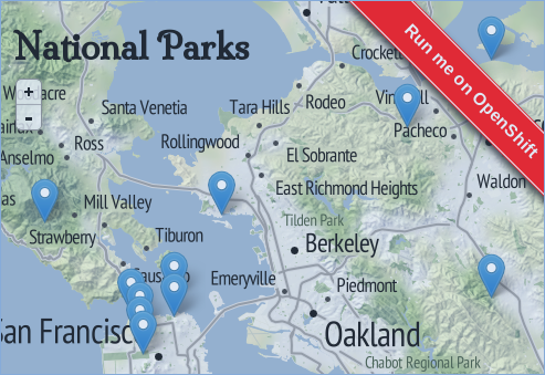
rhc app create nodegis nodejs-0.10 postgres-9.2 --from-code=http://github.com/ryanj/restify-postGIS.gitLive Result
~ related content ~
Web Workflows for Launching Apps
Customizing OpenShift's Web-based App Creation Workflow
Open Source Ribbons for Launching Apps
Instant Hosting of Open Source Projects with GitHub-style Ribbons
Custom Domain Names and SSL
Spatial mapping on OpenShift
Tuning PG
aka, where is my pg_hba.conf, and postgresql.conf?
Some PG tuning notes were recently posted in the OpenShift Online release announcement for April 2014
OPENSHIFT_POSTGRESQL_SHARED_BUFFERSOPENSHIFT_POSTGRESQL_MAX_CONNECTIONSMore general tuning advice: https://wiki.postgresql.org/wiki/Tuning_Your_PostgreSQL_Server
Advanced configurations
- Watch out for statistics collector issues in the pg-9.2 cart
Take a look at the latest from Crunchy Data Solutions!
HA for PG by CrunchyData
See their release announcement for additional details: crunchydatasolutions.com
Including support for LB, geographic failover, Master-slave replication, and more!
Join the Community
- We accept pull requests
- Help with anything from core, quickstarts, and cartridges, to small typo fixes in the command line tools
- PEPs for major feature enhancements
- Contribution Guidelines
- Public Trello cards
- Public Test plans
- Public Bugzilla
- Vote on Features
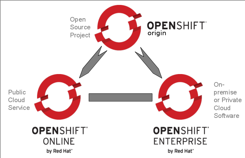
Origin.ly
OpenShift Core Roadmap:
Check out the upstream source:
OpenShift Origin
Try our hosted solution (3 apps free):
OpenShift Online
Request an evaluation for:
OpenShift Enterprise
Thank You!
See my post on this topic for more info: Instant Mapping Applications with PostGIS and Nodejs
Link to these slides: bit.ly/1CWYKkA
See you next time!
--ryanj